I’d like to suggest some destinations in the Iberian Peninsula that are perfect for visiting with your General Aviation aircraft:
If you visit these airfields, you’ll receive a 60% bonus.
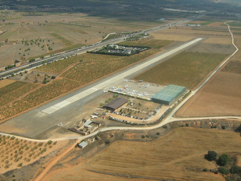
LERE – Requena Airfield
A small airfield located near the renowned Ricardo Tormo Circuit, home to the final stop of the MotoGP World Championship. LERE (Requena Airfield) is not only strategically positioned for motorsport enthusiasts but also serves as a vital base for firefighting aircraft during the summer, thanks to its proximity to several key reservoirs and the Cofrentes nuclear power plant.
Surrounded by a landscape of striking contrasts, pilots can enjoy breathtaking views from the air: to the west, the expansive Buseo, Benagéber, and Contreras reservoirs offer shimmering waters framed by lush pine forests and rugged terrain — an ideal route for scenic flights or aerial photography. To the south, the Cofrentes nuclear power station stands as a modern engineering landmark nestled in the volcanic region of Ayora-Cofrentes, where thermal activity and natural formations give the area a unique geological character.
This combination of natural beauty, technical interest, and nearby touristic attractions — including wineries, mountain villages, and hiking trails — makes Requena airfield an excellent destination for general aviation pilots seeking more than just a place to land. Whether you’re coming for the circuit, the landscape, or a weekend getaway in inland Valencia, LERE welcomes you with open skies and unforgettable views.
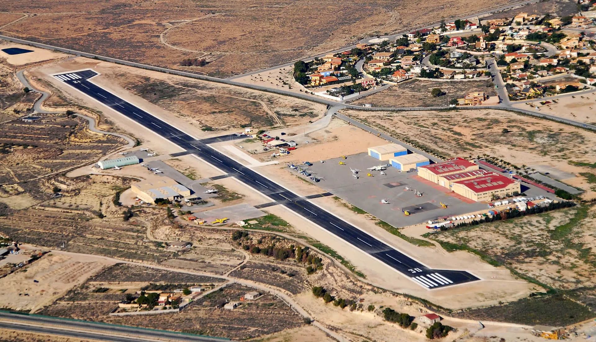
The main airfield in the province of Alicante, LEMU (Muchamiel Airfield) is a highly active general aviation hub located just a few nautical miles north of Alicante International Airport (LEAL). Its strategic coastal location makes it an ideal stop for VFR flights along the stunning Mediterranean corridor.
Approaching from the east, pilots are treated to spectacular views of the Castillo de Santa Bárbara perched atop Mount Benacantil, overlooking the historic city of Alicante and its vibrant waterfront. The descent offers a sweeping panorama of golden beaches, turquoise waters, and the bustling marina — a preview of the dynamic coastal life awaiting below.
But the appeal of Muchamiel doesn’t end with the sea. To the north and west, the terrain quickly rises into dramatic sierras and rugged landscapes dotted with almond and olive groves, small traditional villages, and vineyards. The nearby Serra Grossa and the mountain of Cabeçó d’Or offer not only scenic beauty but also a backdrop ideal for aerial photography, gliding, and sightseeing flights.
Thanks to its proximity to the city of Alicante, the Costa Blanca, and inland mountain ranges, Muchamiel is a gateway to both sun-soaked beaches and rural charm. Whether you’re planning a coastal flight, a weekend city escape, or a scenic tour of Alicante’s natural wonders, LEMU offers a perfect combination of accessibility, beauty, and Mediterranean hospitality.
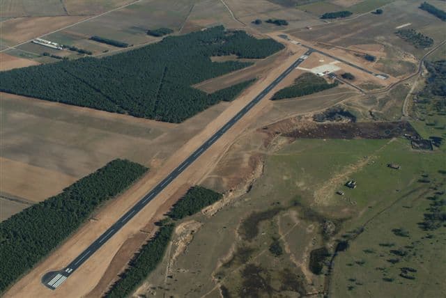
Despite being a lower-category airport, Soria-Garray Airfield (LEGY) boasts a generously long runway, capable of handling larger aircraft — including Spanish Air Force C-130 Hercules, which have been spotted performing training landings here. Its quiet airspace, excellent visibility, and well-maintained facilities make it a hidden gem for general aviation pilots seeking both practicality and charm.
Located just minutes from the historic city of Soria, this airfield is nestled in the heart of inland northern Spain, surrounded by the expansive Castilian plateau and rich natural heritage. The surrounding region offers a scenic approach over pine forests, gentle hills, and the Duero River. The nearby Sierra de la Cebollera and the Picos de Urbión provide a stunning mountain backdrop, especially beautiful during winter and spring.
LEGY is also steeped in history — situated next to the archaeological site of Numantia, one of the most iconic Celtiberian cities of ancient Spain. A short flight from the airfield opens access to historical castles, Romanesque churches, and medieval towns such as El Burgo de Osma or Calatañazor, making it an ideal base for aviation tourism.
Whether you’re planning a cross-country flight, a cultural weekend, or simply looking to explore one of Spain’s most peaceful and picturesque regions from above, Soria-Garray offers a unique blend of aviation capability and Castilian charm.
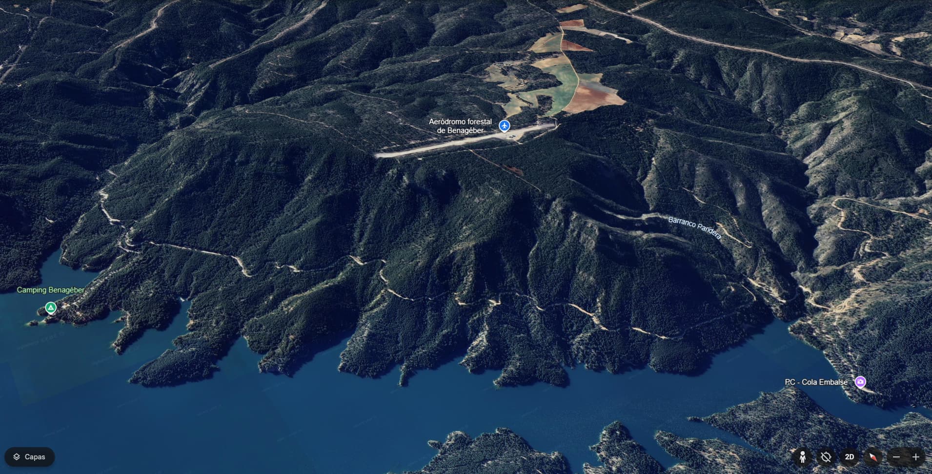
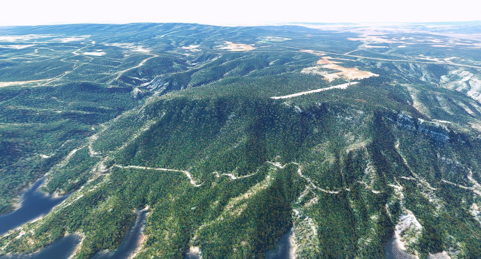
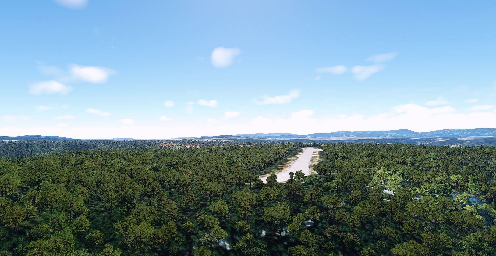
Presentation of the Benagéber Forest Airstrip (LEBR)
Looking for a unique challenge for your VFR flights?
Let us introduce you to the Benagéber forest airstrip, a hidden gem nestled in nature — perfect for pilots who enjoy bush flying and non-conventional landings.
Location
Name: Benagéber Forest Airstrip
Code: LEBR (unofficial, for simulated or recreational use)
Approximate Coordinates: 39.733°N, 1.116°W
Elevation: ~710 meters (2,329 feet)
Surface Type: Compacted dirt / forest terrain
Environment: Mountainous area surrounded by pine trees, near the Benagéber Reservoir
Route from Requena Airfield (LERE)
Distance: ~30 km to the north (approximately 16 NM)
Approximate Heading: 350º from LERE
Flight Time: 10–15 minutes in a light aircraft
Recommendations:
VFR flight under good weather conditions
Ideal for STOL-capable aircraft and bush planes
Watch out for terrain: hills, trees, and limited space
Approach Tips
The airstrip is well-camouflaged among the vegetation, so it’s recommended to fly over the area at low speed to locate it visually.
Prevailing winds usually come from the west, but can vary depending on the season.
Be ready for a go-around — there’s not much room beyond the strip.
Do you accept the challenge?
Try landing there and send us a photo from the strip!
We want to see your bush flying skills and your aircraft in the middle of the forest.
I calculated wrong the time, I was looking at the active flight time, on webpage and thought I read 29, but was 19. Any way there’s the way back, and I’ve saw some wind turbine blades east bound toward the coast. Got do some fly by. Onether thing is that on MSFS there are too many trees, too close to the runway edges. Maybe I should modify the scenery and take them out. trees are easy to take out.
There are many interesting places near our airports that we can showcase. With ideas like this, pilots will discover new spots to enjoy—especially if you fly in VR like I do—and airport owners will benefit from increased traffic to their airfields. I could have specified landing, taking the photo, and returning to LERE to complete the flight.
In the opposite direction, you’ll find even more reservoirs in the area, and one of Spain’s nuclear power plants in Cofrentes.
Do you think that’s a good reason to reduce the minimum flight time? Vote for 10!!
P.S.: In the MSFS2020 marketplace, there’s an addon that replaces the default trees with others of a more realistic size, which greatly improves the experience.
I did vote.. that already. And the addon will see if it really places different trees or as in the real spot it took them away.. otherwise I’ll do it as I did on others too..
In Italy we have airports that are much more dangerous than this one, such as the Chamois altiport and others that I won’t mention now because it’s not the case. However, I’ve never seen this in Spain.